Maine town buried under a foot of snow as nor’easter batters east coast
Two people were killed in Pennsylvania when the storm caused trees to fall on their cars
At least four people were killed after tornadoes and severe storms tore through several states this week.
Widespread thunderstorms rolled across the central and eastern US on Tuesday bringing tennis ball-sized hail, pounding rain and dangerous winds to at least 75 million people.
After lashing parts of Texas, Illinois and Oklahoma, the weather system moved from the northern parts of Indiana and Ohio and western Pennsylvania on its track east, with tornadoes touching down in Georgia, Ohio and Tennessee.
On Wednesday, two people were killed in Pennsylvania when the storm caused trees to fall on their cars, WPVI reported.
Meanwhile, Kentucky Governor Andy Beshear confirmed that at least one victim was killed in the state – as the weather caused a car accident.
After two days of heavy rain, thunderstorms, hail, and tornadoes, the east-ward moving storm system has now hit the US east coast, with severe weather hammering Florida up through New England and the northern border states.
As of Thursday morning, 137,000 homes in Maine were without power after a powerful Nor’easter hammered the state.
WATCH: Chicago weather: Rain, possible severe storms on the way
Multiple people hurt in Texas crash amid severe storms
Multiple people were hurt on Monday in a pileup involving as many as 30 vehicles at an intersection south of Midland, Texas, as high winds blew dust that was making visibility difficult, the Texas Department of Public Safety said.
Texas Highway Patrol Troopers and Upton County Emergency personnel responded to the crash along State Highway 349 around 4:50pm.
The National Weather Service had issued warnings about blowing dust and damaging winds for Monday afternoon in the area.
Motorists were urged to use caution when traveling in West Texas.
WATCH: Severe weather to roar from Texas to Maryland
Watch: Satellite imagery shows atmospheric river moving into California
A late-season atmospheric river that brought heavy rain to California can be seen entering the country over the weekend in this satellite footage shared by Cooperative Institute for Research in Atmosphere (CIRA).
The moisture from the river has moved inland and enhancing the severe weather threat over central US.
‘Strong tornadoes,’ large hail likely, thunderstorms expected across central Tennessee on Tuesday
Three tornadoes in Oklahoma
At least three tornadoes were reported in Oklahoma on Monday evening, according to AccuWeather.
More than eight million people in the Central United States were under tornado watches as a line of storms moved across the state.
Tornado warnings had been in effect for parts of Missouri, Oklahoma and Texas, and expired Monday night. Several warnings expired at midnight.
Severe storms likely Tuesday across much of the eastern US
Severe thunderstorms will move across much of the eastern US on Tuesday, from the Gulf Coast through the Ohio Valley, according to National Weather Service forecasts.
In the midwest and Ohio Vallye Tuesday morning thunderstorms are likely but are expected to taper off early before giving way to more severe storms in the afternoon and evening.
Severe storms including tornadoes are likely Tuesday in much of Ohio as well as parts of West Virginia, Kentucky, and Indiana. Large, destructive hail and strong winds are also possible in the region, according to the NWS.
Storm damage in Tulsa
Authorities reported storm damage northwest of Tulsa, Oklahoma, in the town of Barnsdall.
Houses, trees and power lines were damaged after a possible tornado hit the area, Osage County sheriff Eddie Virden told KOTV-TV in Tulsa.
Storm forecast for Tuesday and Wednesday
The severe weather threat is intensifying from Tuesday and will extend into Wednesday, unleashing powerful tornadoes, damaging winds and hail as large as golf balls in some areas, forecasters say.
The weather system will extend from the northern parts of Indiana and Ohio and western Pennsylvania and move southward.
The risk for tornadoes extends from southeast Indiana across Ohio and over portions of Kentucky, West Virginia and Pennsylvania, the Storm Prediction Centre forecasts.
It will impact the central Gulf coast and eastward to the Chesapeake Bay region and part of the Delmarva Peninsula. Storms in this broad zone will pack strong wind gusts, hail and localised flash flooding.
Some hailstones could exceed 2 inches in diameter and destructive winds could reach speeds of up to 75mph, the centre said.
Storms are likely to reach their peak strength on Tuesday afternoon and evening but could persist overnight in some areas.
“On Wednesday, it appears the primary threat for severe thunderstorms will be for strong wind gusts, and that will be centred on a large portion of the mid-Atlantic coast,” AccuWeather Meteorologist Alyssa Glenny said.
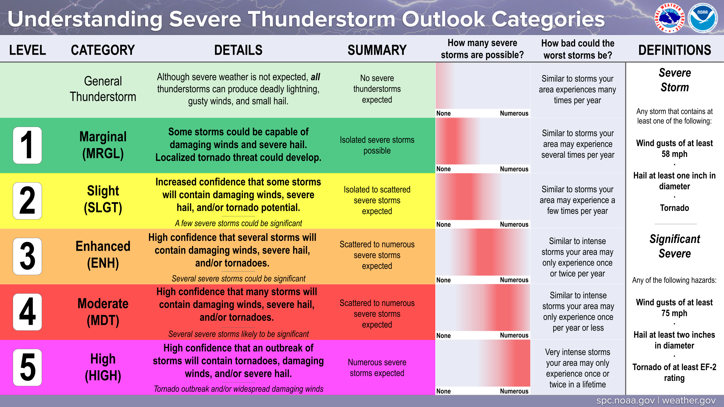
Level 4 warning for storms
Tuesday’s risk for severe storms was upgraded to Level 4 of 5 in much of Ohio and parts of Indiana, Kentucky and West Virginia, where a “substantial severe weather outbreak” is possible, according to the Storm Prediction Centre.
Join our commenting forum
Join thought-provoking conversations, follow other Independent readers and see their replies
Comments