The Independent's journalism is supported by our readers. When you purchase through links on our site, we may earn commission.
Seven beautiful US hikes to kick off your New Year’s fitness resolutions
These outstanding trails will get the blood pumping and showcase some of America’s most photogenic landscapes
If your resolve for maintaining New Year’s fitness resolutions tends to evaporate prematurely, try throwing spellbinding views and incredible wildlife encounters into the mix — by embarking on an exhilarating hike or two.
Not sure where to begin? These seven outstanding trails will provide some inspiration; routes that will get the blood pumping and showcase some of America’s most photogenic landscapes.
They range from accessible strolls to not-for-the-faint-hearted climbs, with moderate trails in between.
One of the most eye-opening winds through an otherworldly canyon in Utah, while Oregon offers a route that comes with views of its highest peak.
In Tennessee, you can trek to a dramatic rock overhang and soak in views of beautiful mountain forests, while in Arizona a bit of all-fours scrambling will launch you to a ridge that’s home to one of the state’s most famous rock formations.
In Montana, there’s a marked trail to one of Glacier National Park’s most famous glaciers, and in California you can venture along the coastline to a waterfall that spills onto a secluded beach.
Have a head for heights? Visit Maine for a challenging ascent that involves clambering up iron rungs bolted into the side of a vertical rock face as vultures wheel in the sky above. The reward — a bird-of-prey view of a glistening bay below.
1. The Narrows, Zion National Park, Utah
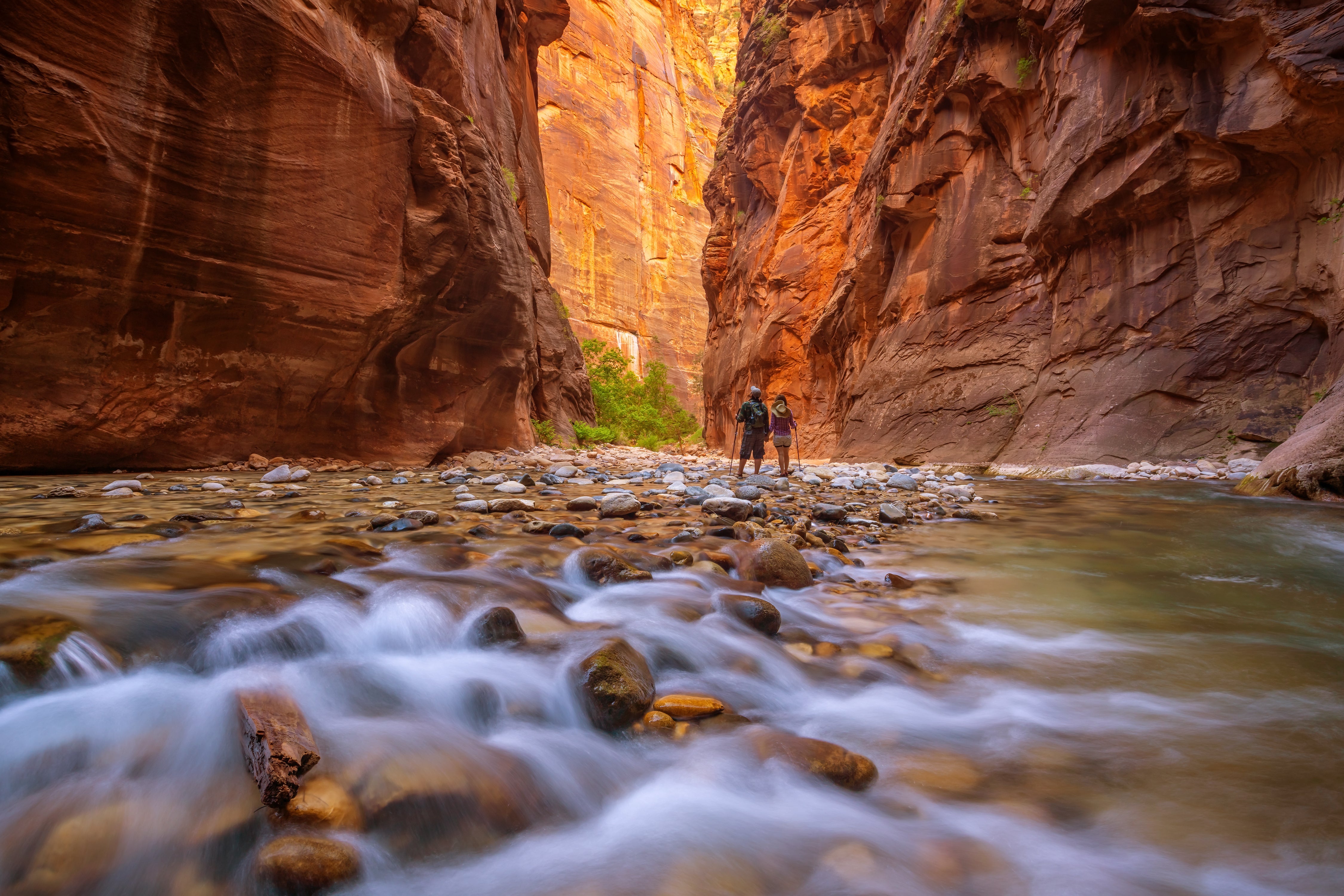
You may want to pack your waders to tackle The Narrows — the slimmest section of Zion Canyon in Zion National Park — because for much of the time you’ll be walking directly in the Virgin River, which flows along it.
That makes the walk rough and slippery by default, but the setting is spectacular — a narrow gorge with dramatic vertical rock faces soaring skywards on either side and an environment where you might spot mule deer, rock squirrels, ringtail cats and tree frogs.


The northbound hike begins in the striking Temple of Sinawava amphitheater, around 160 miles from Las Vegas. Here, you can either set off in the water or keep your gear dry for a short while by venturing along the paved, wheelchair-accessible Riverside Walk, which extends for about a mile.
Around a mile upstream from the end of Riverside Walk, the rock wall opens up on the east side to reveal Orderville Canyon, an eye-opening side canyon. However, the most visually arresting moment is “Wall Street,” which is slightly further north. Here, the canyon is pinched to just 20 to 30 feet in width by rock faces that rise to around 1,000 feet.
The furthest you can hike without a permit is Big Springs, a picturesque cluster of waterfalls just under five miles from the Temple of Sinawava. Getting there and returning is a full day’s hike for most, but you can turn around at any time.
Good to know: Check the weather forecast, river flow and flash flood potential beforehand. The best window is late spring to early fall, when the water is warmest and water levels tend to drop. To reach the Temple of Sinawava, park at the Zion National Park Visitor Center, located at the south entrance by Springdale, then hop on the mandatory shuttle bus.
Great place to stay: Under Canvas Zion (rooms from $270) is a luxury glamping resort minutes from the Zion National Park entrance that features safari-style tents with en-suites.
Read more: Seven remote luxury hotels in America — where wilderness meets five-star comfort
2. Mirror Lake Trail, Mount Hood, Oregon

If you hike the Mirror Lake Trail on Mount Hood, keep your eyes peeled for Douglas squirrels, chipmunks, black-tailed deer and, in winter months, snowshoe hares, as the beautiful forest that envelopes this route is home to them all.
What’s more, enjoying their lush ecosystem doesn’t require much strain.
The easy-to-moderate, clearly marked four-mile walk begins at Mirror Lake Trailhead, located at the Skibowl West parking lot on the south side of Mount Hood, about one mile west of Government Camp village along U.S. Highway 26.
From there, you ascend around 1,300 feet amid old-growth firs and mossy trunks to Mirror Lake, which on a clear day perfectly reflects the snow-capped peak of Mount Hood, Oregon’s highest mountain at 11,249 feet above sea level.
Reaching the lake typically takes between one and two hours, after which a loop around the shoreline reveals bonus viewpoints of Hood’s imposing flanks.
Good to know: The weather can change rapidly around Mount Hood and snow is common from late fall through spring, when snowshoes may be needed. From May through October, you will need a Northwest Forest Pass or an America the Beautiful Pass. However, from November 1 through April 30, a Sno-Park Permit is required.
Great place to stay: To round out the classic Pacific Northwest experience, book Timberline Lodge (rooms from around $220), above Government Camp on the flanks of Mount Hood, where coziness is guaranteed thanks to interiors with stone fireplaces and burnished beams. Exterior seem familiar? It was used as The Shining's Overlook Hotel.
Read more: A seaweed foraging adventure along the Oregon coastline
3. Alum Cave Trail, Great Smoky Mountains, Tennessee

The Alum Cave Trail in the Great Smoky Mountains National Park is a world of towering tulip poplars and maples, babbling streams, and picture-book wildlife, from wild turkeys and black bears to bobcats, white-tailed deer and salamanders.
But as the name suggests, there’s also a cave, of sorts, to explore.
Alum Cave Bluffs is the most popular turnaround point for this well-maintained, 4.6 mile-long route, which takes around three to four hours to complete and begins at the Alum Cave Trailhead between mile markers 10 and 11 along Newfound Gap Road, about eight miles south of Gatlinburg.
You’ll gain around 1,200 feet of elevation and pass through Arch Rock, a dramatic natural stone arch, before reaching Alum Cave Bluffs, which are more of a dramatic rock overhang than a true cave, but impressive, nevertheless. And the landscape views are awe-inspiring.
More experienced hikers can continue to the summit area of 6,593-foot-high Mount LeConte for views that are even more expansive.
Good to know: While there are handrails in steeper sections, be alert to ice during colder months and abrupt weather changes at higher elevations. Parking spaces fill up quickly at the trailhead, so arrive before 8am during peak seasons. A Smoky Mountains parking tag is required.
Great place to stay: Blackberry Farm (rooms from $900), near Walland on the edge of the Great Smoky Mountains National Park, is a storied luxury resort with two outdoor pools, beautifully appointed rooms and three restaurants serving dishes that showcase regional ingredients.
Read more: From foodies to Swifties: America’s music city is the perfect holiday break
4. Cathedral Rock Trail, Sedona, Arizona
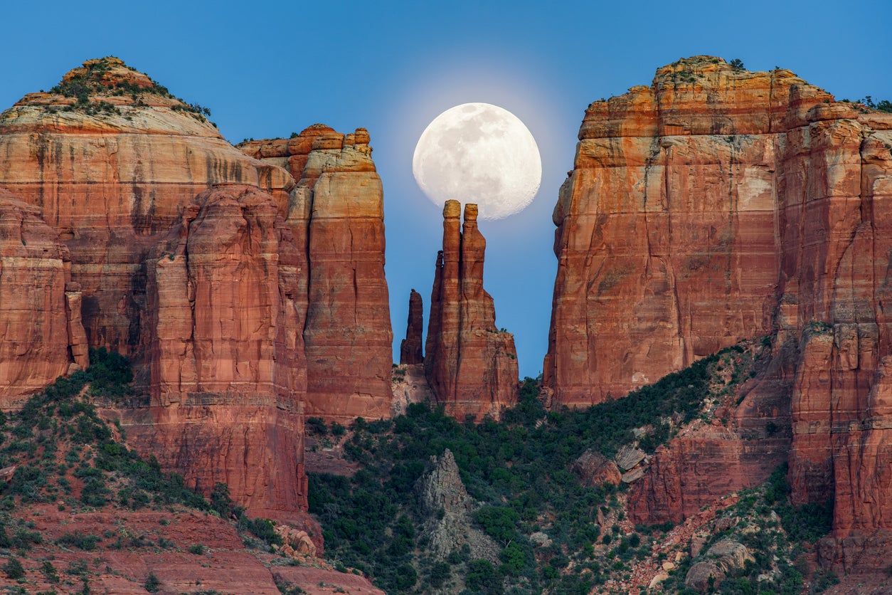
Cathedral Rock Trail is short but very sweet, the endpoint after just three-quarters of a mile being the route’s namesake rock formation: a photogenic cluster of crimson spires that draws visitors from far and wide.
The start point is the Cathedral Rock Trailhead, accessed via the Back O’ Beyond Road, about 10 minutes south of Sedona.
While the trail, which rises around 740 feet, is clearly marked, be prepared for a bit of hands-and-feet scrambling near the top.
Once you’re on the ridge by Cathedral Rock’s towers, you may be joined by collared and whiptail lizards while soaking in the amazing views across the desert to Courthouse Butte and Bell Rock.
Excluding lingering time for the views, most hikers complete the 1.5 mile round trip in 60-90 minutes.
Good to know: Shoes with good grip are vital, carry plenty of water, and start early when temperatures are slightly cooler. To park, you’ll need a Red Rock Pass or America the Beautiful Pass.
Great place to stay: Enchantment Resort (rooms from $700), nestled 20 minutes away from Cathedral Rock at the base of Boynton Canyon, offers 218 rooms, some with private plunge pools and fireplaces, and all with canyon views.
Read more: Scottsdale: The Arizona desert city that defined Hollywood’s golden age is enjoying a comeback
5. Grinnell Glacier Trail, Glacier National Park, Montana
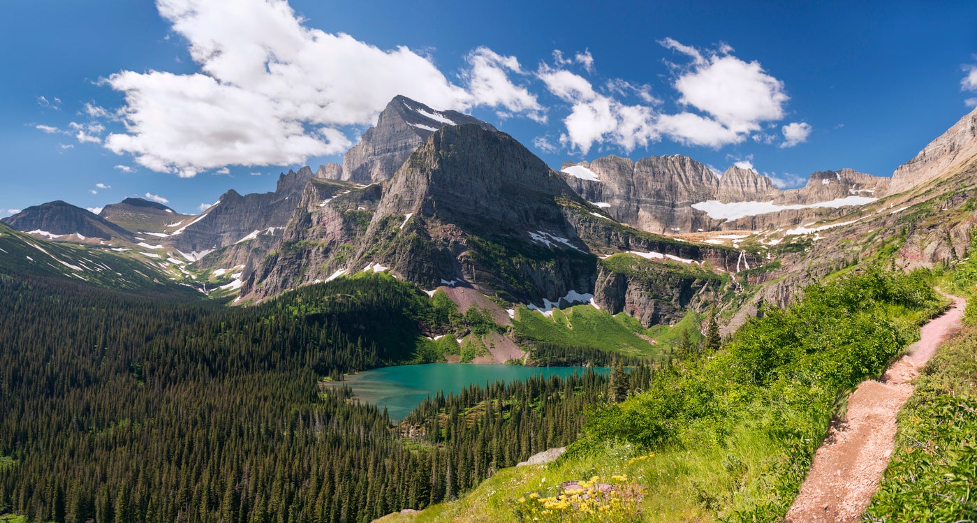
The Grinnell Glacier Trail ranks as one of America’s best all-round hikes, checking boxes for breathtaking scenery, amazing wildlife and sense of achievement.
The epic scenery is present from the outset: the trail — a 10.6 mile, five-to-seven-hour round trip — is signposted from a dramatic corner of Glacier National Park, just south of the Many Glacier Hotel, on the shoreline of Swiftcurrent Lake.
From there, you’ll hike past strikingly turquoise Grinnell Lake and Lake Josephine, framed by rugged peaks, before reaching the spellbinding turnaround point — the edge of Grinnell Glacier, one of the most famous of the park’s 26 or so remaining glaciers.
At this point, you’ll have earned a break, having climbed 1,600 feet to an elevation of 6,500 feet, and along the way you may have spotted grizzly and black bears (usually seen at a distance), mountain goats, bighorn sheep, moose, marmots and pikas. Gray wolves are also present, though you can count yourself exceptionally lucky if you spot one.
Good to know: Carry bear spray and make sure you know how to use it, though rest assured that rangers will close the trail if bear activity is high. Mid-July to September is the best window, but snow can linger even in July. A park entrance pass or America the Beautiful pass is required.
Great place to stay: Many Glacier Hotel (rooms from $300) is in the perfect location for this hike and offers Swiss-style rooms with mesmerizing views.
Read more: Is this America’s best-kept vacation secret? The underrated state that deserves your attention
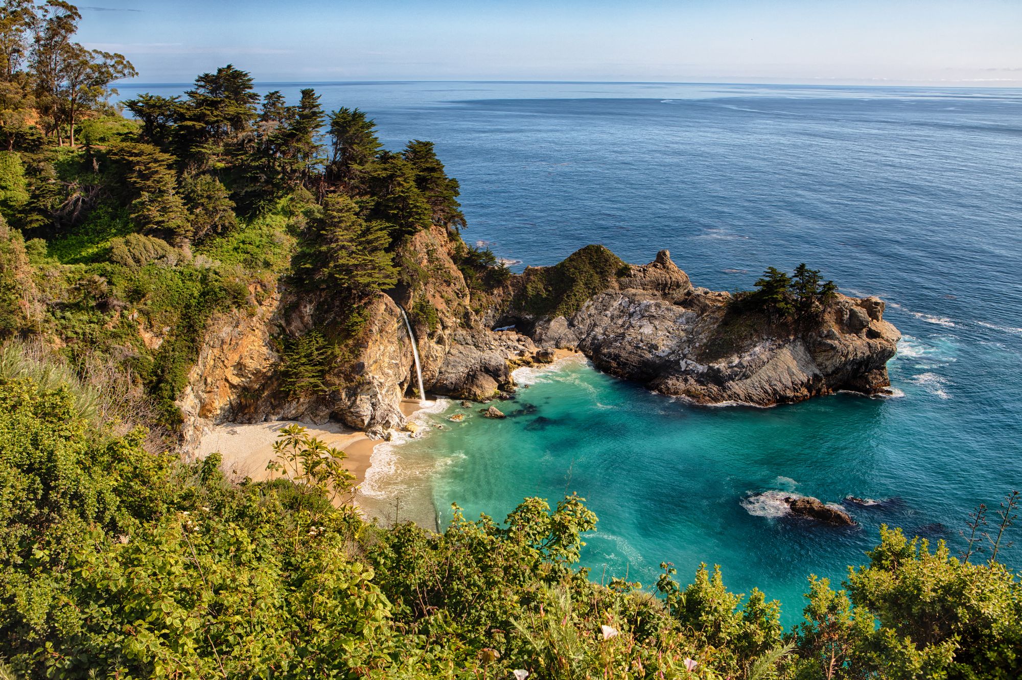
6. McWay Falls Trail, Julia Pfeiffer Burns State Park, California
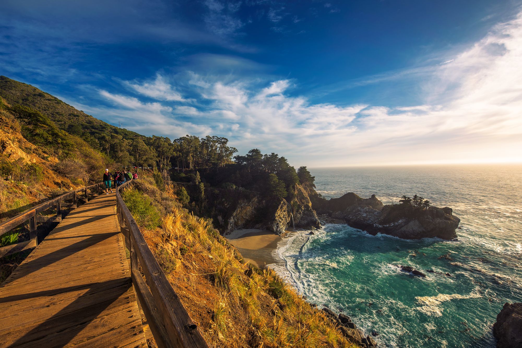
If the priority is maximum scenery for minimal exertion, the McWay Falls Trail in Julia Pfeiffer Burns State Park is for you — at just 0.6 miles as a round trip, with no hills to climb, it’s easily the most accessible walk on our list, but delivers memorably photogenic views.
The trail starts by Highway 1, around 12 miles south of Big Sur village, and leads along the coastline to the 80-foot McWay Falls, a cascade that, extraordinarily, flows directly onto a secluded beach.


It’s a dreamy scene, and there are a host of animals that frequent this stretch of coastline that make it even more enticing, from California sea lions to sea otters, and from brown pelicans to California condors. You may even spot gray whales (between December and April) and blue whales gliding past offshore.
Good to know: Parking is limited, so arrive early or go late. A California State Parks day-use parking fee is required. America the Beautiful passes are not accepted. Also, descending to the beach is not permitted — it’s private and the cliffs are unstable.
Great place to stay: Big Sur Lodge (rooms from $166) is located inside Pfeiffer Big Sur State Park, about 10 miles north of McWay Falls, and features rustic cabins and lodge rooms nestling under towering redwood trees.
Read more: The 9 best California cities and towns to visit, from LA to Santa Barbara
7. Precipice Trail, Acadia National Park, Maine
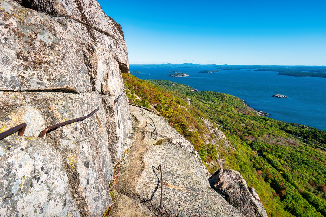
The Precipice Trail in Acadia National Park is the most challenging hike on the list — one to save for when your New Year’s health-kick resolve is laser-focused.
That’s because this not-for-the-faint-hearted ascent involves climbing iron rungs and ladders bolted on to vertical rock faces and negotiating narrow ledges with sheer drop-offs. Metal handholds are available to grip, but there’s little room for error.
If you’re a confident hiker with a head for heights, you’ll be in heaven.
The start point is Precipice Trailhead, on the east side of Champlain Mountain along Park Loop Road, a short drive south of Bar Harbor. From there, wearing shoes with excellent grip, you’ll follow a clearly marked but exposed route up to the summit of Champlain Mountain, 1,058 feet above sea level.
Sweeping views over Frenchman Bay and to neighboring peaks await, and perhaps peregrine falcons and turkey vultures will be keeping an eye on your progress.
The total distance is 2.5 miles, and you should allow three hours to get to the top and back and soak up the views.
Good to know: Grippy footwear is crucial, and avoid the trail in wet, windy or icy conditions. A park entrance pass or America the Beautiful pass is required for parking along Park Loop Road.
Great place to stay: Adrenalin levels will settle fast at refined Claremont Hotel (rooms from $350), overlooking Somes Sound in Southwest Harbor.
Read more: 12 state parks that are just as beautiful as national parks — and they’re free
Join our commenting forum
Join thought-provoking conversations, follow other Independent readers and see their replies
Comments
Bookmark popover
Removed from bookmarks